Thimphu
The jewel in the nation's crown, the Thimphu district includes some of the most advanced and remotest parts of the kingdom. The capital city moves in step with the 21st century with a sophisticated urban lifestyle, while the highland regions of the district, such as Lingzhi, Soe, Naro, and Dagala, are accessible only by foot over cold, rugged, and mountainous terrain.
Thimphu has a total area of about 1,809 square kilometers, with elevations ranging from 1,300 meters to over 7,300 meters above sea level. The district has one Dungkhag and eight blocks.
Besides its position as the seat of government, the district's many glittering monuments, temples, monasteries, and dzongs, as well as premier museums, the National Library, and other key attractions, make it an important stop for tourists and visiting heads of state.
In 1567, a renowned Buddhist master called Lama Tenzin Dendup built a dzong at the present site of Wangdue Tse monastery, which stands on a picturesque knoll overlooking the Thimphu valley.
This first structure was called Dzong Gongma, or "The Upper Dzong", and it housed the palace of the Deb Raja and became an administrative center for the region. At other points in the valley, the Dechenphu and Changangkha temples are dedicated to the two guardian deities protecting the upper and lower halves of the capital, a fact that makes them one of the most frequented places for spiritual offerings. Large numbers of devout Bhutanese from all walks of life arrive daily to circumambulate the two temples and make butter lamp offerings before seeking the beneficence of the guardian spirits.
The Changangkha temple was founded by the illustrious Lama Phajo Drugom Zhigpo in the 13th century and was later enlarged and embellished by his son, Nyima. Today, the temple is considered the spiritual home of children born in the Chang valley, which includes the areas surrounding this ancient temple.
Among the places of spiritual note in Thimphu, the Pangrizampa Lhakhang was built in 1529 by Lam Ngawang Chogyal, who visited Bhutan with his son, who came from Ralung in Tibet. It was first called Druk Phodrangding "The Castle of the Dragon", after the name of an important monastery in Tibet.
The Samarzingkha Lhakhang was built by Tibetan Lama Nayub to cleanse the sins of all sentient beings and generate peace in the world. Situated on top of a mountain at the south end of the valley, Tashigang Goemba stands majestically overlooking the valley. It was while meditating here that the 12th Je Khenpo had a dream in which he was instructed to build the monastery at its present site. Today, it serves as a Geden Lobdra, or monastic school, for some 35 monks.
The Samarzingkha Drana monastery was built by Khenchen Sonam Yodzer, one of the disciples of Gyalsey Tenzin Rabgay, the fourth Druk Desi, at a site blessed in the 8th century by Guru Rinpoche and Khando Yeshey Tshogyal.
Phajoding was first visited by Lam Phajo Dugom Zhigpo, who established Thujidrak on one of the four distinct cliffs overlooking the valley. Later on, the site was visited by eminent religious saints. One of the main temples that is visible on the cliff was built by the 9th Chief Abbot of Bhutan, Sakya Rinchen (1744-55), and the 13th Desi Chogyal, Sherab Wangchuk (1744-63). In 1749, corresponding to the 13th Rabjung, other monasteries that today make up the Phajoding complex were built by the 16th Chief Abbot of Bhutan, Sherab Singye (1784–91), and the 19th Desi Druk Tenzin (1789–92) in 1789.
The Puemo Lhakhang, another temple visible on the mountain slopes, was built by Ngawang Chogyal in the 16th century. Later, in the 18th century, Jamba Lhakhang, Chador Lhakhang, Menlha Lhakhang, and Khachoe Lhakhang were added. Finally, in 1873, the 49th Desi, Kit-shab Dorji Namgyel (1873–79), built his own residence in the area.
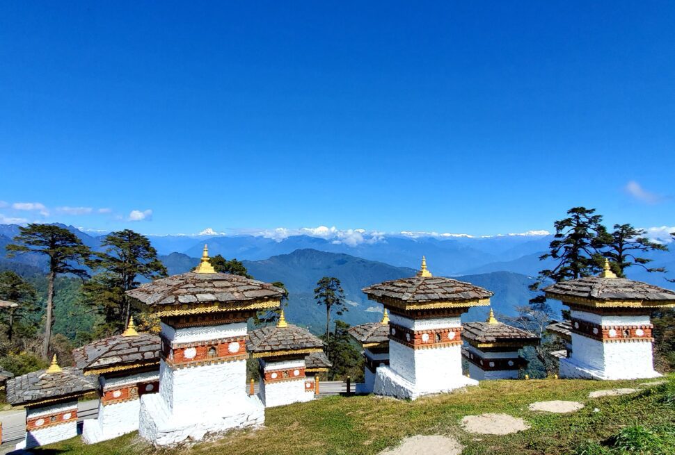
In our own times, the 108 Choetens at Dochula were built at the initiative of Her Majesty Ashi Dorji Wangmo Wangchuck as a tribute to His Majesty the Fourth King, Jigme Singye Wangchuck.
The ethnic composition of Thimphu district is mainly Ngalongpa, a word that means "the earliest risen," perhaps a reference to the fact that they consider themselves the oldest inhabitants of Bhutan. The other ethnic groups are the Bjobs of the highlands of Dagala, Lingzhi, Soe, and Naro, who mainly depend on livestock farming. They also speak Ngalonpakha, sometimes mixed in with some Tibetan. In Thimphu, the capital city, one encounters the widest variety of people from all the other regions of Bhutan. The northern part of the capital skirts the edges of the Jigme Dorji Wang.
Chuck National Park, where many species of flora and fauna thrive. Rice, the staple of the region, is grown extensively by a majority of the people in lowland blocks, while highlanders rely on yak herding. The people of Lingzhi Dungkhag in the remote interiors of the district also collect and sell wild medicinal and aromatic plants. In some parts of the district, people also earn additional income by hunting for the rare and coveted Matsutake mushroom. Thimphu City is undergoing one of the fastest expansions in the kingdom, leading to the Mushrooming in many suburban areas. Traditional mud-rammed homes and paddy fields coexist with some of the most modern construction developments in Bhutan. The two faces of Thimphu mirror the modern dichotomies of Bhutan. In this valley, one can breathe in the fragrance of smoke and incense offerings and hear melodic temple bells while shopping for the latest modern electronics.
A stroll through the city is an opportunity to experience the full ethnic diversity of Bhutan. It is also the summer residence of the Buddhist national clergy and His Holiness the Je Khenpo, the Chief Abbot of Bhutan.
Here you can find traditional Bhutanese paper makers, incense makers, farmers, and vegetable vendors all practicing their art and selling their produce. A short drive to Sangaygang Hill provides an opportunity to pause and reflect on the hustle and bustle of a busy city life.
Paro
There are three temples in the kingdom, and it also boasts the only international airport in the country. oldest and most With its annual bounties of paddy, Paro is justly considered to be the rice bowl of the country. Spread over a total area of 1285.5 sq. km, the region's farms produce some of the finest yields of Bhutan's staple red rice.
One of the most impressive and well-known fortresses in Bhutan, Paro Dzong, was earlier known as Rinchen Pung Dzong, meaning "fortress on a heap of jewels." The name has now been shortened to Rinpung Dzong. It houses both a flourishing school of monastic study as well as government administrative agencies, the most notable being the Dzongda.
or district administrator's office, and the Thrimkhang, or district judiciary. Standing on a scenic knoll at one end of Paro Valley, the ruins of the Drukgyal Dzong, "Fortress of the Victorious Drukpa People" is a reminder of the numerous Tibetan attempts to invade Bhutan. Built by Zhabdrung Ngawang Namgyel in 1649, the fortress helped the Bhutanese defenders protect the sovereignty of the kingdom. But perhaps more importantly, Paro is known for its wealth of sacred temples and monasteries. Chief among these holy sites, the Taktshang, or "Tiger's Nest Monastery," clings precariously to a cliff 3,000 feet above the valley floor. Legends tell us that in the eighth century, Guru Padmasambhava flew to the cliff on the back of a tigress and meditated on the cliff for three months. Centuries later, in 1684, the 4th Deb Raja, Gyalsey Tenzin Rabgye, considered by many to be the "heart-son" of the Zhabdrung, built a monastery on the site and gave it the name Taktshang, as a reminder of its origins in the Padmasambhava legends.
Goensakha Lhakhang was built in the 14th century by Pha Drung Drung, the great grandson of Lama Phajo Dugom Zhigpo, along with the Jangsabi Lhakhang. The Gorina Lhakhang and the Kila Goemba were built by the Dupthob ("one who has earned great merit", or in Sanskrit, Siddha) Paw Dorji, a saint of the 16th century.
The Druk Choeding Lhakhang, where the Zhabdrung faced off his first Tibetan invasion, was founded in 1529 by Ngawang Chogyal, another saint.
The unusual and circular Dungtse Lhakhang, reminiscent of the Shanag, or black hat, worn by Bhutanese Black Hat dancers, was built by the great "Builder of Iron Chain Bridges," Drupthob Thangtong Gyalpo, in 1433. According to legend, he visited Bhutan in the 14th century at the behest of Ap Chundu and Jowo Drakey, the two guardian deities of Paro and Haa valleys. Having lived in Paro for a significant portion of his life, Drupthob Thangtong Gyalpo is also credited with extracting iron from Woochu village in Paro to build numerous iron suspension bridges in Bhutan and across the Himalayas.
It is said that while he was meditating, Thangtong Gyalpo saw visions foretelling the establishment of a monastery that would bear the name Tachog Lhakhang. The prophecy was fulfilled by his son Dewa Zangpo in the 14th century, and the building was later renovated in the 17th century during the reign of the 4th Deb Raja.
Kyichu Lhakhang, which is only a few kilometers from the Paro town at Bondey, was built by Songtsen Gampo in 659 AD. It is one of 108 temples built by the Tibetan king in a day (according to legend) throughout the Himalayan region. The temple was later visited and blessed by such spiritual personages as Guru Padmasambhava, Lama Phajo Dugom Zhigpo, and Je Sherub Gyeltshen.
Kunzang Chholing Lhakhang was built in the 15th century by Terton Dorji Jonpa, while the Sangchen Choekhor Goemba was a seat of the Zhabdrung Sungtruls, or "speech incarnations," of Zhabdrung Ngawang Namgyel. The temple that stands on the site today was established in 1763 by the second Sungtrul Choglay Sacha Tenzin.
Yutoe Goemba was established by Terton Jatshon Nyingpo, alias Ngachang Huna Membar, in the 16th century. The temple was named Yutoe, "temple on the tip of the turquoise," as it is believed to have been built atop a turquoise projection emerging from a lake beneath the temple.
Ragoedrak Lhakhang, founded by Guru Padmasambhava in the 8th century A.D. along with Dzongdrakha Goemba. The Nangkar Goemba was founded by Lama Phajo Dugom Zhigpo, and its sacred artefacts include images of Phajo and his consort Sonam Palden.
Paro Valley is home to the Parop people, the original settlers of the valley, known across Bhutan for their industriousness. The valley boasts the Taa Dzong National Museum, the premier repository of Bhutanese history in the kingdom.
Like the people of the neighboring Haa valley, Parops too celebrate their new year on the 29th of the tenth month of the Bhutanese lunar calendar. During the New Year's celebrations, families come together to share the season's bounty and conduct special ceremonies and prayers to ward off evil and bring good fortune in the coming year.
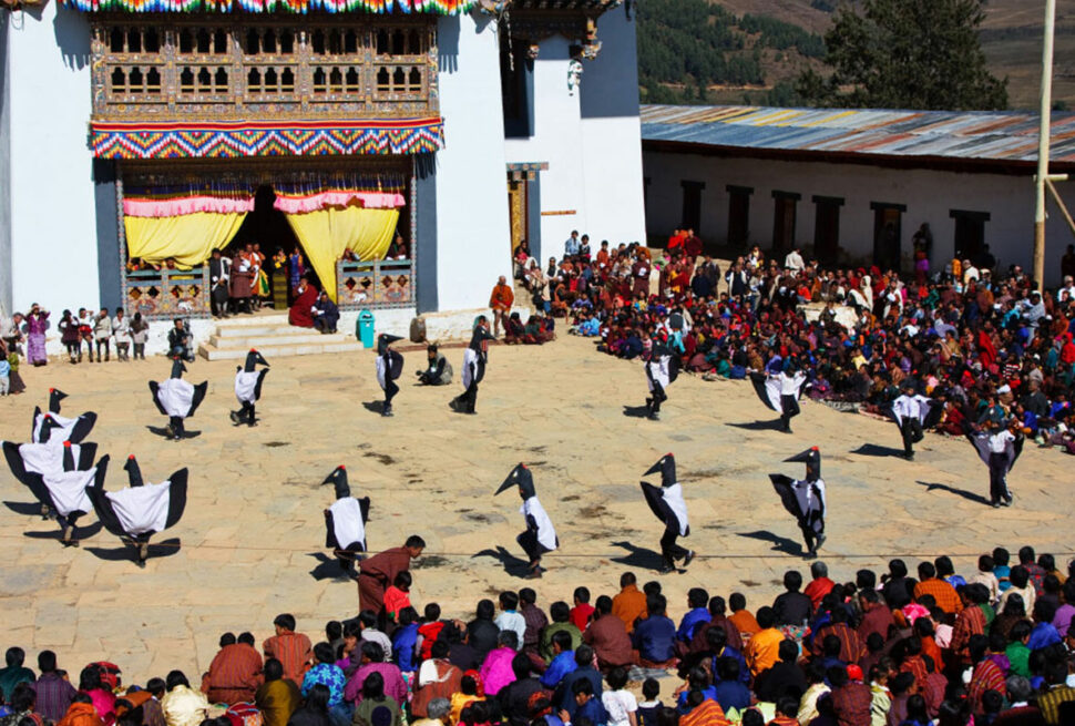
The five-day Paro Tshechu festival is one of the biggest religious celebrations of the Bhutanese year. Mask dances are performed to illustrate Buddhist moral tales and the lives of various Buddhist masters. Bhutanese people from all walks of life join the residents of Paro in their best attire to attend the dances. During the festivities of the final day of the Tshechu, a popular folkdance called the Wochubi Zhey commemorates historical events. Smaller ceremonies are also conducted by the region's people throughout the year to honour various guardian deities, such as the Bjishi Gom of Gensakha village, Donka Tshen in lower Paro, and Droloe Nyekha in Lomikha.
Tourism has brought a boom to Paro. Among the valley's economic assets are some of the most renowned hotels and resorts. The incredibly beautiful and intricate Zhiwa Ling stand stands shoulder to shoulder with upscale resorts Uma and Amankora. Paro Kyichu Resort, another respected hotel group in the kingdom, also has its flagship property in the district.
The Olathang Hotel and the Gangtey Palace are other properties in the valley that enhance tourism. Other newer hotels, such as the beautifully constructed Dhey Kyed, on a scenic hill with some of the best views in the valley, infuse the local economy with vitality.
Among the other, more positive, impacts of tourism in the region has been the revival of old crafts such as pottery, thangka painting, bootmaking, and other "living arts" that were previously threatened by modernization.
Punakha
Inextricably linked to some of the most momentous events in Bhutanese history, Punakha deserves its reputation as one of the most beautiful and significant regions at the heart of Bhutanese culture.
It was in Punakha that Zhabdrung Ngawang Namgyal first established the Chhoesid Nyiden, the dual system of government. In 1651, Punakha was chosen to be the capital from which the newly unified kingdom would be administered.
Two and a half centuries later, in 1907, Punakha was again the place where the Bhutanese people elected the first king, Gongsar Ugyen Wangchuck. The epoch-making event took place in the hallowed halls of the Punakha Dzong. The first session of the kingdom's National Assembly was also held in the Punakha Dzong in 1955.
Today, Punakha's significance to the Bhutanese nation is emphasized by the fact that it remains the winter residence of the national clergy and His Holiness the Je Khenpo, the Chief Abbot of Buddhist Bhutan.
Punakha boasts several ancient temples that constitute some of the most significant spiritual treasures in Bhutan. The Chimi Lhakhang, for instance, honors Lama Drukpa Kuenley, revered across the Himalayas as the "Divine Madman". The Talo Goemba was the home and birthplace of the speech incarnation of the Zhabdrung.
The Talo Sanga Choling was founded by Chogtrul Jigme Singye (1742–89), the 4th reincarnation of Lama Thripa Galsey Tenzin Rabgye. In the early 19th century, Jigme Drakpa (1791–1830), the third-mind reincarnation of Zhabdrung Ngawang Namgyel, renovated the area and built a monastery. He also installed the temple statues he had brought from Samye in Tibet.
The Nyeb Goemba was founded in the 14th century by the revered Lama Thinley Rabyang. A sacred relic in this temple is the Mask of the Raksha, a mythic bull mentioned in Bhutanese scriptures. The mask, fashioned from the rare and expensive Za wood (polished knots and burls of wood treasured in Bhutan for their magical properties), serves as Nangter, or "Inner Spiritual Treasure," for the people in the region.
The Tshephu Monastery was founded by Tsephu Trulku Gyeltshen Pelzang, a follower of Saint Goe Tsangpa. Among the relics at the monastery is a gold-plated replica of Zhabdrung's hat.
It is said that in the 15th century, corresponding to the 8th Rabjung, Lama Drukpa Kuenley was returning from Tibet when he rested at a village called Jiligang. On arrival, he tossed the partially burned wood he had carried with him during his journey. When it fell to the ground, it sprouted into a vigorous and leafy tree. The lama saw this as an auspicious sign and later decided to build a temple near the tree. Later in the 18th century, Chogtrul Jigme Singye (1742–89), the fourth reincarnation of Lama Thripa (Gyalse Tenzin Rabgay), visited the place and built the temple that stands on the grounds today.
Besides its temples and monasteries, Punakha is also famous for its hot springs, and the gentle terraces that line its slopes are a treat to the eyes.
The valley is home to people known as Punaps. The Punaps are good-humored and hard-working people, and Dzongkha is the main language spoken in the region.
With an immense wealth of flora and fauna, the region includes parts of Jigme Dorji Wangchuck National Park within its boundaries.
The wide range of altitude, from approximately 1,200 to 4,800 meters, accompanied by abundant rainfall of about 500–1500 mm, allows cultivation of a variety of crops. Double-cropping of paddy is a special agricultural practice in Punakha. The region is also a major producer of rice, wheat, chillies, persimmon, bananas, and many other fruits.
The district has warm and humid summers with cool winters.
The Layaps and Lunaps who live in the highlands of Gasa district migrate to Punakha in the winter.
Among the festivals in the region, the Punakha Domchen, honoring the guardian deity of Bhutan, includes colorful reenactments of the numerous battles Bhutan fought with Tibetan marauders. Bringing history to life, Pazaabs, or militiamen in full traditional gear, play out mock battles with men dressed in Tibetan garb.
Other seasonal celebrations in Punakha include the Talo Tshechu, Dado Tshechu, Yusa Tshechu, and the singing of Lolay, melodies for a good year sung by children as they solicit treats from home to home.
Rafting on Punakha's Mochu River provides tourists with a unique opportunity to enjoy the valley from a different perspective.
Haa
Haa district is the ancestral home of the Great Royal Grandmother, Her Royal Highness Ashi Kesang Choden Wangchuk, whose grandfather, Gongzim Ugyen Dorje, commissioned the construction of what was formerly the district center, the Wangchu Lo Dzong. This structure shares a floor plan that is similar to the Wangdichholing Dzong in Bumthang, which became the seat of the first and second kings of Bhutan. With a great deal of the arkwork and carvings coordinated by the same artisans who built its predecessor in Bumthang, the Wangchu Lo Dzong was built to replace the older Dumchog Dzong, which was destroyed by fire. The prefix sar, meaning new, is sometimes used to distinguish this dzong from other similar structures in the country since its relatively recent establishment in 1915 sets it apart from other dzongs in the country.
Another fortress, Dobji Dzong, located 11 kilometers away from Chunzom towards Haa proper, was built in 1531 by Ngawang Chogyal. Perched atop a ridge, one side of which is flanked by a hair-raising ravine descending to the basin of the Pachu-Wangchu, the five-story fortress was used mainly as one of the main centers of Drukpa Kagyu teachings.
The region of Haa runs north-east to south-west and adjoins the districts of Paro, Chhukha, and Samtse, covering an area of 1706.8 sq. km. It is one of the smallest districts in the country.
In its fertile valleys, the people of Haa grow high-altitude crops such as wheat, potatoes, barley, and millet. The population of the region numbers about 12,000 people in 63 villages that fall within six blocks, or district sub-divisions.
Besides the Wangchu Lo Dzong, a series of picturesque temples line the valleys of Haa. Of these, the Lhakhang Karpo (white temple) and Lhakhang Nagpo (black temple) are both located in the tiny village of Dumchoe. Built in the 7th century AD, Lhakhang Karpo’s sparkling white walls can be seen from a distance in the foothills of the three towering mountains venerated in the region as the Rigsum Gonpo, the geological monuments of the Bodhisattvas Jampelyang (Manjushri), Chana Dorji (Vajrapani), and Chenrizing (Avaloketeshvara). Similarly, Lhakhang Nagpo is easily distinguished by its grayish-black wall situated a little higher up the mountain from the white temple.
The hundred-year-old monastery of Tagchu Goemba in Lungse Kha village under the Isu block was founded by Dali Lama Sangay Jamtsho. It is believed to have been built along the lines of the Nub Dali Dzong in Tibet, where Lama Sangay Jamtsho served as the abbot of the Tibetan monastery.
The Shekhar Drak temple is ensconced at the foot of a cliff, with its walls organically melded into the rock, and appears as if it is a natural outgrowth of the landscape rather than something that was imposed on it.
A few unique customs and traditions set the people of Haa apart from Bhutanese in other parts of the country. For instance, Haaps, as the people of Haa are known, celebrate their new year much earlier than people in other parts of the country. The New Year in Haa arrives on the 29th day of the 10th month of the Bhutanese calendar (as early as November). Perhaps because it arrives sooner than the other conventional new years, the Haap new year is known as Lomba, a phrase that means “to carry the year”. The people of Haa begin their new year celebrations with a dish called Habi Hoente, a dumpling of buckwheat filled with pungent grated turnip, dried turnip greens, mushrooms, garlic, onion, and chopped cabbage. Ginger, walnut, chilli powder, salt, butter, and oil seeds such as sesame and san poppy may be added to the dumplings to enhance flavors and recipes according to the preferences and means of the individual households.
As in the other high-altitude regions of the country, yak is a significant contributor to the traditional economy, and a dried variety of yak cheese called "habi ruto” is a famous specialty of the region.
Alongside traditional Buddhist practices, the Haaps also continue their old shamanistic traditions, the most notable of which is the annual ceremony to honor the guardian diety of the valley, Ap Chhundu. The men all worship the diety in his form as Phola Masang Chhundu, believed to have been a favorite lieutenant of Zhabdrung Ngawang Namgyel. The rituals include the sacrifice of a yak to Ap Chhundu in return for his favors over the valley, which include the deflection of all misfortunes in the valley for a full year until the next ceremony.
Chhukha
Until recently, the ancient ruins of Chhukha Dzong stood watch over two of the biggest hydropower generators in the country, a testament to the region’s past significance as well as its significant importance to the economy of Bhutan. Formerly the seat of the Chhukha Penlop, one of the wealthiest patrons of the Zhabdrung, who also had formal ties to the Raja of Cooch Behar, the region today boasts not just power projects but also other major industries such as Bhutan Ferro Alloys Limited.
Pagsamkha in Chhukha was considered one of the four gateways to Bhutan, and many British political officers entered Bhutan via the Buxa Duar and then through Chhukha to Punakha, the kingdom’s ancient capital, where many important negotiations took place.
With its area encompassing some of the most dense sub-tropical forests in the country, Chhukha also has many important plant and animal species. The first highway connecting the capital, Thimphu, with India was built in 1961, further stimulating economic activity. Because it served as a gateway to India, Chhukha was long used by many western Bhutanese traders as a commercial lifeline to the Kingdom. Chhukha’s undisputed position as the kingdom’s top revenue earner survives to this day, and while the old Chhukha Dzong may no longer be standing, in its place is a new Zangthopelri, the Great Copper Palace of Padsambhava, built by the Chhukha Hydropower Corporation, a fitting tribute to the enduring vibrancy of the region.
In the religios sphere, the Chhukha region draws significance from the fact that it was blessed by many renowned Buddhist masters, including Lama Drakpa Jamtsho, who lived in the 17th century.
Lama Drakpa Jamtsho established a monastery called the Jabar Goemba in Nagja under Betina block in Chapcha, a valley surrounded by five mountains with an auspicious resemblance to the five religious hats, or Ring Nga, traditionally worn by lamas. The main relic in the monastery is the phurba, or ritual dagger, believed to have miraculously flown there from Tibet. Even to this day, the relic is said to appear as if it is attempting partial flight. There is also a sacred volume of scriptures in the Jaber Goemba written on ancient sheaves of traditional handmade paper, or Deysho.
Another historically important monastery in Chhukha is the Tshamdrak Goemba, located in the Chapcha valley. This monastery was also founded in the 17th century by Lama Ngawang Drakpa, who was a revered teacher of the Gangtey, Trulku Tenzin Legpai Dendup. Later, Lama Ngawang’s brother, the 13th Chief Abbot of Bhutan, Je Khenpo Yonten Thaye (1771–75), lived in the valley. In the Tshamdrak monastery, relics include the “100 ceremonial drums” discovered from a nearly cypress tree and a large stone slab attributed to Ap Chundu, the guardian diety of Haa Valley, who was also the personal Choesung, or Dharma Protector, of the Lama Ngawang Drakpa.
Chhukha is home to two major ethnic groups, the Ngalops and the Lhotshampas (Southern Bhutanese who originally came from Nepal). Among the Lhotshampas, one comes across several subgroups: the Tamangs, the Sherpas, the Rais, the Limbus, and the Lepchas. The languages spoken include Dzongkha, Lhotsha Kha, Lepcha Kha, Tamang Kha, and Sherpa Kha. The Rais and the Limbus are generally Hindus, while the Sherpas, the Tamangas, and the Lepchas are all Buddhists like the original Ngalop inhabitants.
The Ngalops live in homes built from rammed earth and stone with intricate wood carvings, while the Lhotshampa live in Nepalese-style houses roofed with thatch and straw.
Because of the diversity of the region, non-Buddhist festivals and dances form part of the regional celebration, especially during the auspicious seasons of Diwali and Duserra, along with the traditional holidays such as the Losas, or New Year, and Thrue, or the Blessed Rainy Day.
The Chhukha region boasts the Chhukha and Tala hydropower projects, which regularly generate the highest earnings for Bhutan. The power is generated by tapping the fast-running river that is formed by the confluence of the Wangchu and Paachhu rivers further north. Once it enters the Chhukha region, the “run of the river” is tapped to generate over 336 megawatts of power for the Chhukha project and 1200 megawatts for the Tala project.
Besides being exported to India, the hydroelectricity also powers the rest of Bhutan and Chhukha’s flagship industries, which include factories manufacturing carbide, chemicals, ferrosilicon, steel, cement, polymer, polythene, cement, fruit products, and beverages.
Dagana
Wedged like an upturned Tsholham (traditional Bhutanese boot) below the major western valleys, the verdant region extends south to the kingdom’s border with India. Nearly 80 percent of the district is under forest cover, and hardy trees like chaamp, augury, chirpine, and sal abound.
Dagana is famous for its organge plantations, and rice cultivated in its valleys finds its way to the capital and other parts of the country.
From the mid-17th century up to the turn of the 20th century, the successive Daga Penlops who governed the region were major political players, and they helped the Zhabdrung in his efforts to establish and consolidate a unified system of administration in the Kingdom.
To make it easier to govern the region, the Daga Penlops subdivided their region into the Ling Sum, or “Three Gardens” and the Lung Sum, or “Three Forests." Today, some of those traditional divisions have changed, and portions of the old Lung Sum now lie within Chhukha district.
Summers in Dagana are hot and humid, while winters are cool and dry.
The historic Daga Trashiyangtse Dzong, from which the district takes its name and which today serves as the district administration center, was established in 1651 by Zhabdrung Ngawang Namgyel. Other places of interest in the region include the three stone megaliths known as Do Namkhai Kaw, or “Sky Pillar Rock”, Do Kelpai Genthey, or “the Rock of Ancient Steps”, and Tha Namkhai Dzong, or the “Frontier SKy Fortress”.
The stone megaliths of Do Namkhai Kaw stand facing the Dzong from an opposite slope across the valley. More than 20 metres high, the tips of the megalith and the golden cupola of Daga Dzong are believed to be of the same height, although each appears to be taller than the other when viewed from the other side. The megalith is said to have miraculously conveyed the message that the dzong would collapse if it were built any higher than it currently stands.
The Shathong Lhakhang was founded by Dupthob (Siddhi) Shawa Ripa, a renowned Buddhist master believed to have lived for about nine hundred years. The Siddhi first established a meditation centre where the present people stand. Accounts differ on the derivation of the temple’s name. One version states that while in meditation, Shawa Ripa came across the name “Shathong” which loosely translates as “the place from which the stags were seen”. Down the ages, the temple received many important visitors, including the 13th Desi, Chogyal Sherab Wangchuk, the 16th Desi, and the Je Khenpo Sherub Sengye.
The Nyindukha Lhakhang is another important religious center in Dagana. Located in Kharling Block, it was founded by Chholay Namgyal (1708–36), the first speech reincarnation of Zhabdrung Ngawang Namgyel. The temple is known for its store of sacred artifacts.
There are two ethnic groups in Dagana: Ngalops of western Bhutanese origin and Lhotshampas, or southern Bhutanese settlers. Agriculture is the main source of livelihood for the region’s people, and the settlements are fairly dispersed and homesteads are remote compared to others in the country. More recently, the government resettlement programs have added to the ethnic diversity, bringing in Khengpa people from the central Zhemgang district, Bumthap people from Bumthang, and Tshangla and Kurtoep people from the far east of Bhutan.
Today, Dagana farmers produce a significant portion of the citrus mandarins (oranges) and cardamoms grown in the country. Studies have also deemed the region fit for the production of other cash crops such as ginger, mango, green gram, and mustard. The mandarin grown in the district is mainly sold to the modern integrated fruit processing plant the government has established in the region, providing economic incentives for farmers while encouraging them to explore other forms of horticulturistic production.
In addition to agriculture, the economy of the region is supported in part by the skills of local craftspeople such as blacksmiths and woodcarvers, whose work sometimes finds its way into the markets of the capital and other towns in the kingdom. More recently, government initiatives to boost the economy of the region include the establishment of food processing plants that make it easier for cultivators to add value to their cash crops. Animal husbandry is another source of income for the people of Dagana.
The Lhotshampas and other ethnic groups add colour to the region with their diverse languages, music, festival customs, and cultural celebrations.
Gasa
Gasa, in the extreme north-west of Bhutan, shares its borders with the other western Bhutanese districts of Punakha, Thimphu, and Wangduephodrang, with Tibet to the north.
The total area of this starkly beautiful region is 4409.30 sq. km. Elevations in the district range between 1500 and 4500 meters above sea level. It is not surprising, then, that the region experiences extremely long and hard winters and short but beautiful summers. With a scant 2000 mm of rain per year, 35 percent of the area is composed of scrub forest, while fir trees comprise another 27 percent of the total area. Another 15 percent of the land cover is mixed conifers, and broad-leaved forests constitute a mere four percent. Tsamdos, or traditional pasturelands, make up about 19 percent of land use. The region also boasts the sources of two major rivers in Bhutan, the Phochhu and the Mochhu, as well as one of Bhutan’s highest peaks, the Masagang.
The region is administered by the beautiful Gasa Trashi Thongmoen Dzong, built in 1648. Named after the region’s protecting diety Trashi Thongmoen, the Gasa Dzong is a unique circular structure with three Ta Dzongs (watchtowers) placed at strategic points. The watchtowers of the dzong are believed to resemble tormas, or ritual cake offerings associated with ceremonies to appease the guardian diety, Yeshey Gonpo or Mahakala.
The natural splendor of Gasa is unparalleled in the country. The region has some of the highest peaks in the kingdom, arrayed like the teeth of a saw in a protective natural border with the Tibetan autonomous region. Over a hundred glacial lakes that are at the foot of these greater Himalayan peaks feed some of the major river systems in the country, including the Phochhu and Mochhu rivers, which join further downstream to form the Sunkosh, which eventually drains into the Bay of Bengal.
A famed series of hot springs, or Tshachhus, with renowned medicinal properties are another important natural resource in the district, drawing numerous locals as well as tourists. Some of these medicinal waters are only frequented by the local people of Lunana and Laya (sub-divisions of Gasa) because of their remoteness.
This wild and breathtaking (literally!) region boasts an incredible diversity of wildlife, including Bhutan’s national animal, Takin, the elusive Snow Leopard, the Red Panda, Mountain Goats, and Blue Sheep. The region’s flora includes the national flower, the blue poppy.
Each year, a number of tourists pass through the region along its popular trekking trails, including the famous Snowman, one of the longest and most arduous treks in the world. The region’s high altitude and extreme climate make it difficult to practice agriculture, but livestock is a mainstay, particularly the rering of yaks, which are often referred to by the region’s people as norbu rinpoche, or precious jewel.
There are some 13 well-known religious monuments in the region, including Zabsel and Phulukha Choeten, the Three Lhakhang, Dung Goemba, Drophel Choling, Yonzho Lhakhang, Jangchuk Choling, Sebji Goemba, Bumpa Lhakhang, Tshodzong Lhakhang, and Dzongridra Lhakhang.
The first Deb Raja of Bhutan, Tenzin Drugyel, came from the well-known house of the Hobtsho lamas, who were famous in Gasa. The ruins of the raja’s ancestral manor, or Nagtshang, can be seen to this day.
The strong and rugged people of Gasa celebrate their annual festivals with a great deal of fun and festivity. Among the festivals, the Auwlay in the fall and the Bongko in the spring are well known and popular. A rich repertoire of folk songs complements the celebrations, the most popular being the Goen Zhey, a song celebrating the arrival of Zhabdrung Ngawang Namgyel to Bhutan, and Ya Laybe Lhadai Gawo, a tribute to the strength, beauty, and loyalty of yaks.
The women of this region have facial features that are distinct from those of other women in Bhutan, and their great love of coral and turquoise jewellery, colourful clothing, and conical bamboo hats immediately set them apart in any crowd. Like other parts of Bhutan, weaving is a household enterprise, and the women use looms known as Zum to weave spun yak hair and wool into clothing that protects them from rain and moisture and keeps them warm in the cold weather.
In the summer, the semi-nomadic people of Gasa’s two main regions, Laya and Lunana, live in the mountains. They migrate to the warmer valleys at lower elevations to barter their produce of yak dairy and meat in the lower valleys as the cold winter sets in.
In recent years, the highly valued medicinal cash crop, Cordyceps sinesis, has become a major source of income in the region, rivalling the traditional yak-based economy.